Evo i opisa
Catalogue Note
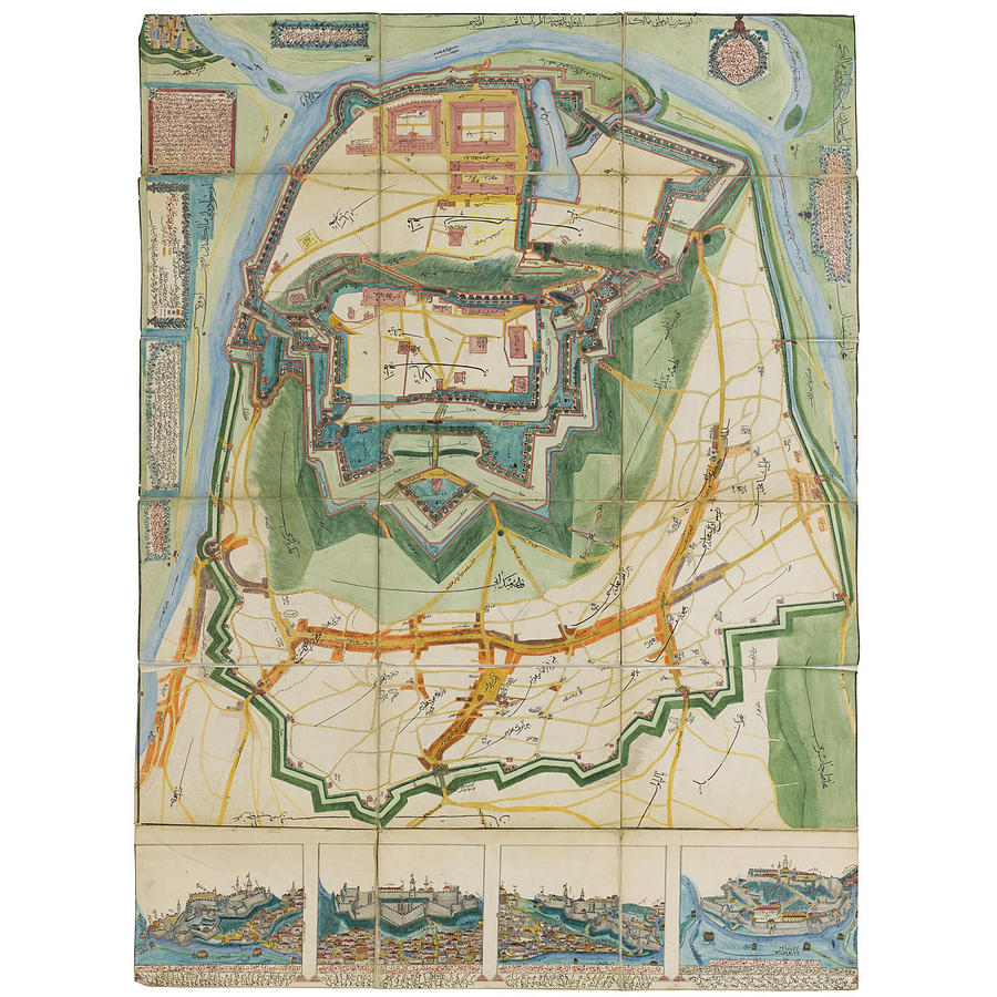
inscriptions
Top right corner, in red letters, inside a wreath:
'A map of Belgrade Castle, in the Ottoman Empire, in the European part, located in Serbia (Serbistan), between Hungary (Macaristan) and Khravadistan (Croatia?), bordering the provinces of Temişvar (Timisoara in Romania) and Seyram'.
Top left, in red letters, in a rectangle with a leaf border:
a couplet in praise of Belgrade:
'It is written that Egypt and Syria are both but the ornament of Baghdad,
Travelling the whole world, there isn't the like of Belgrade'
Top left, in red letters, in box with thick red border (summarised):
The cartographer laments the mistakes in the map, and excuses his lack of training. He says that the map came into being following a meeting with various men of knowledge, during which it was desired that the mistakes of former maps should be corrected. The cartographer explains that the map shows the various fortifications, including the c. 36,000 palisades erected in the time of the governor Abdulrahman Pasha, as well as various places and streets in the surrounding area. The cartographer explains that from the Istanbul gate (Istanbul kapisi), on the exterior walls at the very bottom of the map, to the Finger Gate (Parmak kapisi), shown at the top right of the map, is about 25 minutes walk. The date of completion is given as 1284, corresponding to 1867-8. This is the year that the Ottomans ceded Belgrade, though no mention of this is made on the map.
Along the upper left hand side of the page:
1) A key to the surround area, giving colours for shops and commercial buildings, mosques, hammams, dervish lodges etc.
2) A key to the fortress itself
Along the bottom are four views of the city and fortress from various angles.
Ottoman maps such as the present example draw on a cartographic tradition that arose in the wake of Sultan Mehmed II's increase in the patronage of art and architecture in the mid-fifteenth century. An official court historian was appointed to chronicle the Ottoman dynasty and the series of sahnames (royal histories) that followed came to be illustrated by the first half of the sixteenth century and took their place within Ottoman historiography as records of the might and power of the Ottoman Empire. Whilst urban topography was essentially non-existent within the overall context of Islamic painting before the first half of the sixteenth century, a distinctive Ottoman cartographic element becomes apparent in manuscript illustration. Indeed the illustrated histories of the Ottoman Empire are now considered an important addition to the corpus of Turkish miniature painting. For a discussion of Ottoman maps and illustrations from the sixteenth century see J.M. Rogers, 'Itineraries and Town Views in Ottoman Histories', in J.B. Harley (Ed.), History of Cartography, vol.2, Book I, Chicago, 1992, pp.228-255.


